Polity Territory List
A viewset for viewing and editing Polity Territories.
GET /api/sc/polity-territories/?format=api&page=10
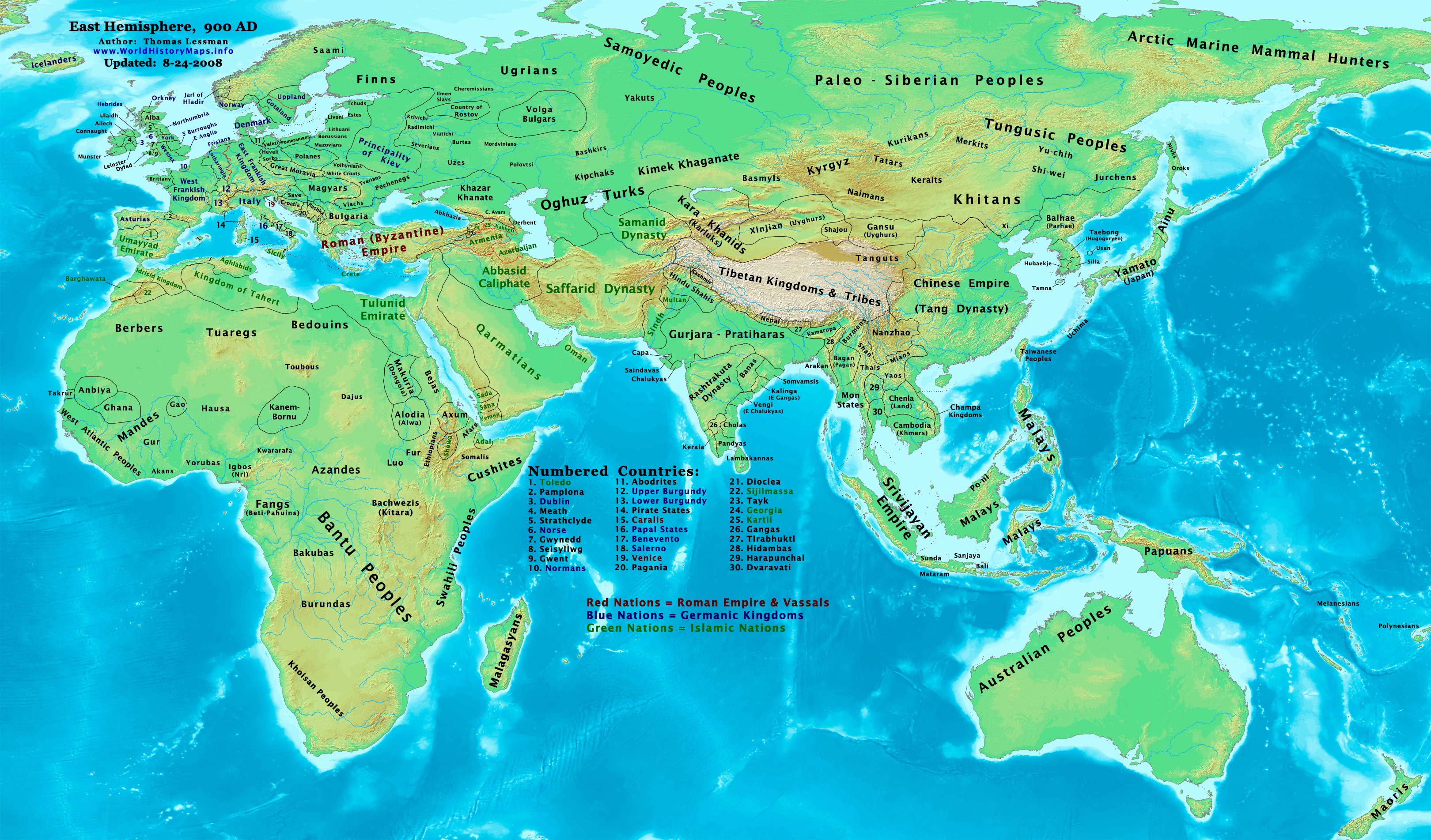
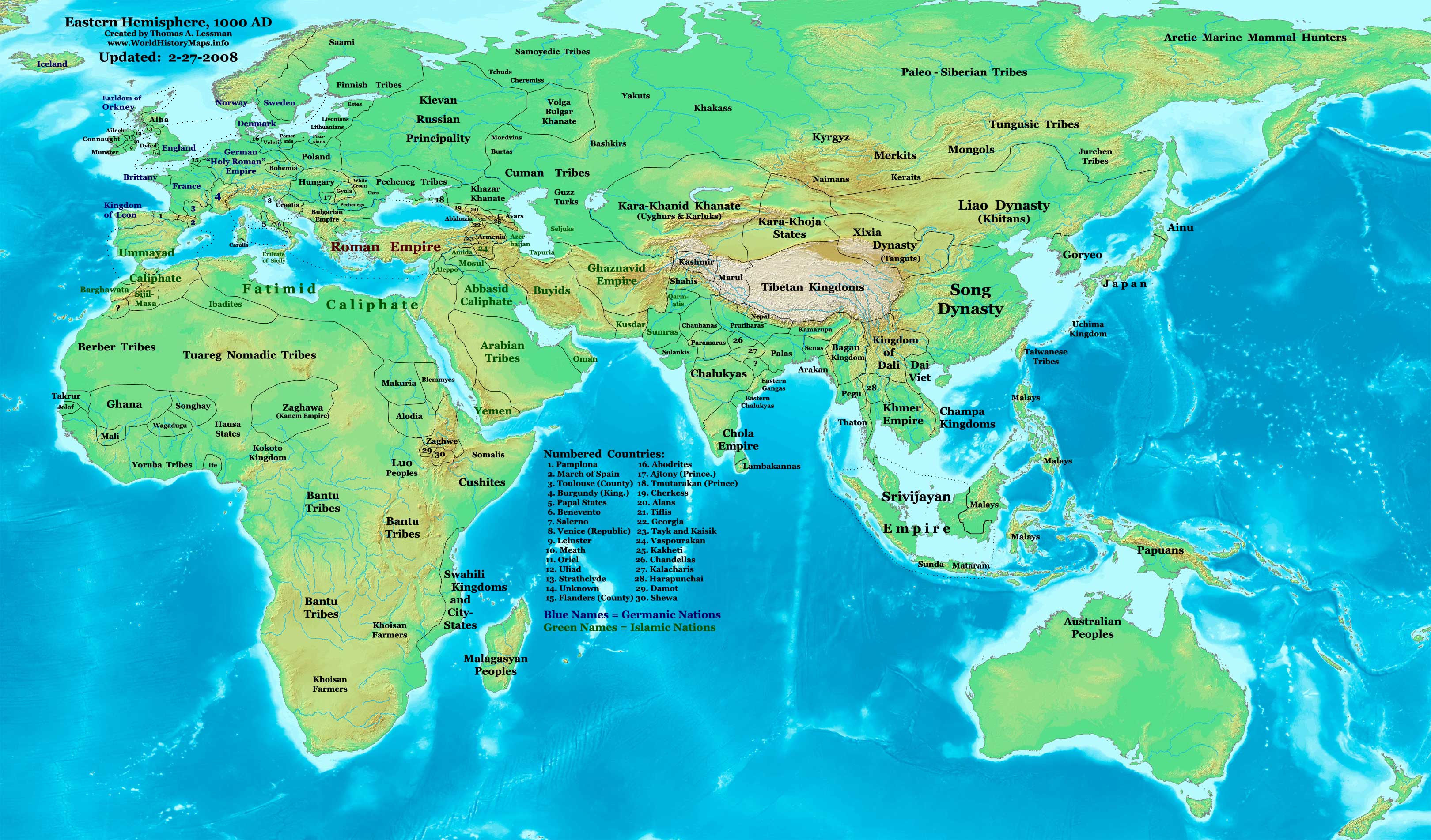
{ "count": 606, "next": "https://seshat-db.com/api/sc/polity-territories/?format=api&page=11", "previous": "https://seshat-db.com/api/sc/polity-territories/?format=api&page=9", "results": [ { "id": 832, "polity": { "id": 566, "name": "fr_france_napoleonic", "long_name": "Napoleonic France", "start_year": 1816, "end_year": 1870 }, "year_from": 1870, "year_to": 1870, "tag": "TRS", "is_disputed": false, "is_uncertain": false, "name": "Polity_territory", "polity_territory_from": 1000000, "polity_territory_to": 1000000, "comment": null, "description": " in squared kilometers. In the mid-nineteenth century France expanded its overseas territories to include huge areas of West Africa following the start of the French conquest of Algeria, and later in Indochina and parts of the Pacific. By 1870 the overseas territories covered nearly 1million square kilometres." }, { "id": 833, "polity": { "id": 786, "name": "gb_british_emp_2", "long_name": "British Empire II", "start_year": 1850, "end_year": 1968 }, "year_from": 1881, "year_to": 1881, "tag": "TRS", "is_disputed": false, "is_uncertain": false, "name": "Polity_territory", "polity_territory_from": 20090019, "polity_territory_to": 20090019, "comment": null, "description": " in squared kilometres.§REF§(Smith 1882: 3. https://www.zotero.org/groups/1051264/seshat_databank/items/AW5H8NPI.§REF§" }, { "id": 834, "polity": { "id": 785, "name": "ye_qasimid_dyn_222222", "long_name": "Qasimid Dynasty XXXXXXX", "start_year": 1637, "end_year": 1805 }, "year_from": null, "year_to": null, "tag": "TRS", "is_disputed": false, "is_uncertain": false, "name": "Polity_territory", "polity_territory_from": 848116, "polity_territory_to": 848116, "comment": null, "description": " in squared kilometers.The above is an approximate estimate based on the above map showing the territory in 1675 drawn onto google maps. Needs a much more accurate confirmation from the scholarship. Once the Ottomans had been expelled from Yemen, the Qasimid dynasty continued to expand its territory for more than 200 years. At its height it stretched from Hadramawt in the east, north to Asir (now part of Saudi Arabia).§REF§Hestler 1999: 24. https://www.zotero.org/groups/1051264/seshat_databank/items/RH82MHZP§REF§ " }, { "id": 836, "polity": { "id": 601, "name": "ru_soviet_union", "long_name": "Soviet Union", "start_year": 1918, "end_year": 1991 }, "year_from": 1923, "year_to": 1924, "tag": "TRS", "is_disputed": false, "is_uncertain": false, "name": "Polity_territory", "polity_territory_from": 18072800, "polity_territory_to": 19008300, "comment": null, "description": "The U.S.S.R. was the successor to the Russian Empire of the tsars. Following the 1917 Revolution, four socialist republics were established on the territory of the former empire: the Russian and Transcaucasian Soviet Federated Socialist Republics and the Ukrainian and Belorussian Soviet Socialist Republics. On December 30, 1922, these constituent republics established the U.S.S.R. Additional union republics (Soviet Socialist Republics) were set up in subsequent years: the Turkmen and Uzbek S.S.R.’s in 1924, the Tadzhik S.S.R. in 1929, and the Kazakh and Kirgiz S.S.R.’s in 1936. In that year the Transcaucasian Republic was abolished and its territory was divided between three new republics: the Armenian, Azerbaijan, and Georgian S.S.R.’s. In 1940 the Karelo-Finnish, Moldavian, Estonian, Latvian, and Lithuanian S.S.R.’s were established. The Karelo-Finnish S.S.R. became an autonomous republic in 1956, leaving a total of 15 union republics (soyuznye respubliki). \r\n\r\n\r\n§REF§John C. Dewdney et al., “Soviet Union,” Encyclopedia, Encyclopædia Britannica, last modified 2023, accessed November 22, 2023, https://www.britannica.com/place/Soviet-Union.<a href=\"https://www.zotero.org/groups/1051264/seshat_databank/items/TWGEBIMJ\" target=\"_blank\" class=\"fw-bolder\"> <b> Zotero link: TWGEBIMJ</b></a>§REF§" }, { "id": 837, "polity": { "id": 601, "name": "ru_soviet_union", "long_name": "Soviet Union", "start_year": 1918, "end_year": 1991 }, "year_from": 1924, "year_to": 1929, "tag": "TRS", "is_disputed": false, "is_uncertain": false, "name": "Polity_territory", "polity_territory_from": 19008300, "polity_territory_to": 19151400, "comment": null, "description": "The U.S.S.R. was the successor to the Russian Empire of the tsars. Following the 1917 Revolution, four socialist republics were established on the territory of the former empire: the Russian and Transcaucasian Soviet Federated Socialist Republics and the Ukrainian and Belorussian Soviet Socialist Republics. On December 30, 1922, these constituent republics established the U.S.S.R. Additional union republics (Soviet Socialist Republics) were set up in subsequent years: the Turkmen and Uzbek S.S.R.’s in 1924, the Tadzhik S.S.R. in 1929.\r\n\r\n\r\n§REF§John C. Dewdney et al., “Soviet Union,” Encyclopedia, Encyclopædia Britannica, last modified 2023, accessed November 22, 2023, https://www.britannica.com/place/Soviet-Union.<a href=\"https://www.zotero.org/groups/1051264/seshat_databank/items/TWGEBIMJ\" target=\"_blank\" class=\"fw-bolder\"> <b> Zotero link: TWGEBIMJ</b></a>§REF§" }, { "id": 838, "polity": { "id": 601, "name": "ru_soviet_union", "long_name": "Soviet Union", "start_year": 1918, "end_year": 1991 }, "year_from": 1929, "year_to": 1936, "tag": "TRS", "is_disputed": false, "is_uncertain": false, "name": "Polity_territory", "polity_territory_from": 19151400, "polity_territory_to": 22067200, "comment": null, "description": "" }, { "id": 839, "polity": { "id": 601, "name": "ru_soviet_union", "long_name": "Soviet Union", "start_year": 1918, "end_year": 1991 }, "year_from": 1936, "year_to": 1940, "tag": "TRS", "is_disputed": false, "is_uncertain": false, "name": "Polity_territory", "polity_territory_from": 22067200, "polity_territory_to": 22276236, "comment": null, "description": "" }, { "id": 843, "polity": { "id": 571, "name": "ru_romanov_dyn_2", "long_name": "Russian Empire, Romanov Dynasty II", "start_year": 1776, "end_year": 1917 }, "year_from": 1800, "year_to": 1850, "tag": "TRS", "is_disputed": false, "is_uncertain": false, "name": "Polity_territory", "polity_territory_from": 17000000, "polity_territory_to": 21000000, "comment": null, "description": "<b>Territory 1776</b>§REF§“Russia 1776 - David Rumsey Historical Map Collection.” Accessed December 2, 2023.<a href=\"https://www.zotero.org/groups/1051264/seshat_databank/items/IMFRZU2C\" target=\"_blank\" class=\"fw-bolder\"> <b> Zotero link: IMFRZU2C</b></a>§REF§\r\n\r\n\r\nMuscovy, Russia, and Siberia\r\n\r\nBaltic Region\r\n\r\nEastern Europe\r\n\r\nCentral Asia\r\n\r\nCaucasus\r\n\r\n<b>Territory 1800</b>§REF§Rein Taagepera, “Size and Duration of Empires: Systematics of Size,” Social Science Research 7, no. 2 (June 1, 1978).<a href=\"https://www.zotero.org/groups/1051264/seshat_databank/items/EI7GRCPX\" target=\"_blank\" class=\"fw-bolder\"> <b> Zotero link: EI7GRCPX</b></a>§REF§\r\n\r\n\r\nExpansion into Central Asia\r\n\r\nIncorporation of Eastern Poland\r\n\r\nAcquisition of Crimea\r\n\r\nAlaska\r\n\r\n<b>Territory 1850</b>§REF§“Russia in the 19th Century Map,” accessed December 2, 2023.<a href=\"https://www.zotero.org/groups/1051264/seshat_databank/items/XPETX686\" target=\"_blank\" class=\"fw-bolder\"> <b> Zotero link: XPETX686</b></a>§REF§\r\n\r\nExpansion into Central Asia \r\n\r\nFurther Expansion in the Caucasus\r\n\r\nAdditional Areas in Eastern Europe\r\n\r\n<b>Territory 1900</b>§REF§Ivan D. Sytin (1851-1934), “Ethnographic Map of the Russian Empire, 1914.”Accessed December 2, 2023.<a href=\"https://www.zotero.org/groups/1051264/seshat_databank/items/UIJCX4S6\" target=\"_blank\" class=\"fw-bolder\"> <b> Zotero link: UIJCX4S6</b></a>§REF§\r\n\r\n\r\n\r\nComplete Control of Central Asia\r\n\r\nConsolidation in the Caucasus\r\n\r\nPolish and Finnish Territories" }, { "id": 844, "polity": { "id": 571, "name": "ru_romanov_dyn_2", "long_name": "Russian Empire, Romanov Dynasty II", "start_year": 1776, "end_year": 1917 }, "year_from": 1850, "year_to": 1900, "tag": "TRS", "is_disputed": false, "is_uncertain": false, "name": "Polity_territory", "polity_territory_from": 21000000, "polity_territory_to": 22000000, "comment": null, "description": "" }, { "id": 845, "polity": { "id": 600, "name": "ru_romanov_dyn_1", "long_name": "Russian Empire, Romanov Dynasty I", "start_year": 1614, "end_year": 1775 }, "year_from": 1650, "year_to": 1700, "tag": "TRS", "is_disputed": false, "is_uncertain": false, "name": "Polity_territory", "polity_territory_from": 9500000, "polity_territory_to": 12000000, "comment": null, "description": "The ascension of the Romanov dynasty in 1613 marked a period of recovery and territorial expansion. Under Tsars like Michael Romanov and his successors, Russia expanded eastward into Siberia, securing territories from various indigenous peoples and rival states.\r\n\r\nConquest of Siberia: Throughout the 17th century, Russia's conquest of Siberia was a major factor in its territorial expansion. This extended Russia's domain across northern Asia to the Pacific Ocean.\r\n\r\nWars and Treaties: Russia's wars with Poland, Sweden, and the Ottoman Empire in the late 17th and early 18th centuries led to significant territorial gains. Key treaties like the Treaty of Stolbovo in 1617 and the Treaty of Kardis in 1661 defined Russia's western borders with Sweden. The Treaty of Andrusovo in 1667 and the Eternal Peace Treaty of 1686 with Poland-Lithuania gave Russia control of territories in Eastern Europe, including parts of Ukraine.\r\n\r\nPeter the Great’s Reign (1682-1725): Under Peter the Great, Russia expanded its territory significantly. The Great Northern War (1700-1721) against Sweden led to Russia gaining access to the Baltic Sea and establishing Saint Petersburg in 1703. This was a crucial territorial and strategic gain for Russia.§REF§Rein Taagepera, “Size and Duration of Empires: Systematics of Size,” Social Science Research 7, no. 2 (June 1, 1978).<a href=\"https://www.zotero.org/groups/1051264/seshat_databank/items/EI7GRCPX\" target=\"_blank\" class=\"fw-bolder\"> <b> Zotero link: EI7GRCPX</b></a>§REF§§REF§“Historical Atlas by William R. Shepherd - Perry-Castañeda Map Collection - UT Library Online,”.<a href=\"https://www.zotero.org/groups/1051264/seshat_databank/items/96J9SE2U\" target=\"_blank\" class=\"fw-bolder\"> <b> Zotero link: 96J9SE2U</b></a>§REF§" }, { "id": 846, "polity": { "id": 600, "name": "ru_romanov_dyn_1", "long_name": "Russian Empire, Romanov Dynasty I", "start_year": 1614, "end_year": 1775 }, "year_from": 1700, "year_to": 1750, "tag": "TRS", "is_disputed": false, "is_uncertain": false, "name": "Polity_territory", "polity_territory_from": 12000000, "polity_territory_to": 14000000, "comment": null, "description": "" }, { "id": 847, "polity": { "id": 409, "name": "bd_bengal_sultanate", "long_name": "Bengal Sultanate", "start_year": 1338, "end_year": 1538 }, "year_from": 1500, "year_to": 1500, "tag": "TRS", "is_disputed": false, "is_uncertain": false, "name": "Polity_territory", "polity_territory_from": 144000, "polity_territory_to": 144000, "comment": "in squared kilometers. Bangladesh comprises \"an area of 144,000 square kilometers\" <a class=\"fw-bold\" href=\"https://www.zotero.org/groups/1051264/seshat_databank/items/RBQ75QDX\">[Hasan 2007, p. 7]</a> and Ala al-Sin Husayn (1493-1519) \"occupied every part of the country, pushing its western frontier past Bihar up to Saran in Jaunpur and reduced the kingdoms of Orissa in the southwest, Arakan in the southeast, and Tripure in the east to vassalage.\" <a class=\"fw-bold\" href=\"https://www.zotero.org/groups/1051264/seshat_databank/items/RBQ75QDX\">[Hasan 2007, p. 16]</a>", "description": null }, { "id": 848, "polity": { "id": 780, "name": "bd_chandra_dyn", "long_name": "Chandra Dynasty", "start_year": 900, "end_year": 1050 }, "year_from": null, "year_to": null, "tag": "UND", "is_disputed": false, "is_uncertain": false, "name": "Polity_territory", "polity_territory_from": null, "polity_territory_to": null, "comment": null, "description": "in squared kilometers.<br>“Their empire embraced a large area in Vanga and Samatata comprising the whole of southern and southeastern Bangladesh and extending as far northeast as Sylhet area.”§REF§\"History\". <i>Banglapedia</i>: <a rel=\"nofollow\" class=\"external free\" href=\"http://en.banglapedia.org/index.php/History\">http://en.banglapedia.org/index.php/History</a>§REF§“The Candras, who started as the rulers of Candradvīpa, expanded their territory to the whole of Vaṅga and then to Samataṭa.”§REF§Furui. 2020. Land and Society in Early South Asia: Eastern India 400–1250 AD. London; New York: Routledge: 31. <a rel=\"nofollow\" class=\"external free\" href=\"https://www.zotero.org/groups/1051264/seshat_databank/items/84Q49F5\">https://www.zotero.org/groups/1051264/seshat_databank/items/84Q49F5</a>§REF§“From the tenth century to the third decade of the 13th century, Samataṭa was ruled by the kings based in Vaṅga like the Candras and the Senas.”§REF§Furui. 2020. Land and Society in Early South Asia: Eastern India 400–1250 AD. London; New York: Routledge: 30. <a rel=\"nofollow\" class=\"external free\" href=\"https://www.zotero.org/groups/1051264/seshat_databank/items/84Q49F5\">https://www.zotero.org/groups/1051264/seshat_databank/items/84Q49F5</a>§REF§" }, { "id": 849, "polity": { "id": 779, "name": "bd_deva_dyn", "long_name": "Deva Dynasty", "start_year": 1150, "end_year": 1300 }, "year_from": null, "year_to": null, "tag": "UND", "is_disputed": false, "is_uncertain": false, "name": "Polity_territory", "polity_territory_from": null, "polity_territory_to": null, "comment": "in squared kilometers<br>“It is not possible to ascertain the extent of their empire, but the fragmentary information supplied by the three plates seem to indicate that they held sway over Samatata.” <a class=\"fw-bold\" href=\"https://www.zotero.org/groups/1051264/seshat_databank/items/BSB9HGAR\">[Chowdhury 1965]</a>", "description": null }, { "id": 850, "polity": { "id": 778, "name": "in_east_india_co", "long_name": "British East India Company", "start_year": 1757, "end_year": 1858 }, "year_from": null, "year_to": null, "tag": "TRS", "is_disputed": false, "is_uncertain": false, "name": "Polity_territory", "polity_territory_from": 1294994, "polity_territory_to": 1294994, "comment": "in squared kilometers\"In 1833, a detailed calculation indicated that the Company had established control over 500,000 square miles of territory in India. <a class=\"fw-bold\" href=\"https://www.zotero.org/groups/1051264/seshat_databank/items/EV56DSWK\">[Bowen 2009]</a>", "description": null }, { "id": 851, "polity": { "id": 783, "name": "in_gauda_k", "long_name": "Gauda Kingdom", "start_year": 600, "end_year": 625 }, "year_from": null, "year_to": null, "tag": "UND", "is_disputed": false, "is_uncertain": false, "name": "Polity_territory", "polity_territory_from": null, "polity_territory_to": null, "comment": null, "description": "in squared kilometers“Towards the close of the sixth century AD the kingdom of Gauda emerged in parts of western and northern Bengal under the later Guptas. By the beginning of the seventh century shashanka captured power in Gauda. Magadha formed a part of his dominions.”§REF§\"History\" <i>Banglapedia</i>: <a rel=\"nofollow\" class=\"external free\" href=\"http://en.banglapedia.org/index.php/History\">http://en.banglapedia.org/index.php/History</a>§REF§“However, this decline was halted by Sasanka [the king], who occupied a number of territories, including Pundavardhana to the north, regions as far west as the city of Benares, and land south to Kongoda, just south of Orissa.”§REF§Middleton, J. 2015. “Gauda Kingdom” in <i>World Monarchies and Dynasties</i>. Available online at: ProQuest Ebook Central: 330. <a rel=\"nofollow\" class=\"external free\" href=\"https://www.zotero.org/groups/1051264/seshat_databank/items/R59KKIJP\">https://www.zotero.org/groups/1051264/seshat_databank/items/R59KKIJP</a>§REF§" }, { "id": 852, "polity": { "id": 250, "name": "cn_qin_emp", "long_name": "Qin Empire", "start_year": -338, "end_year": -207 }, "year_from": -290, "year_to": -290, "tag": "TRS", "is_disputed": false, "is_uncertain": false, "name": "Polity_territory", "polity_territory_from": 340000, "polity_territory_to": 340000, "comment": null, "description": "KM2. §REF§(Chase-Dunn spreadsheet)§REF§<br>316 BCE territory doubled after conquest over Shu. §REF§(Keay 2009, 83)§REF§" }, { "id": 853, "polity": { "id": 250, "name": "cn_qin_emp", "long_name": "Qin Empire", "start_year": -338, "end_year": -207 }, "year_from": -270, "year_to": -270, "tag": "TRS", "is_disputed": false, "is_uncertain": false, "name": "Polity_territory", "polity_territory_from": 820000, "polity_territory_to": 820000, "comment": null, "description": "KM2. §REF§(Chase-Dunn spreadsheet)§REF§<br>316 BCE territory doubled after conquest over Shu. §REF§(Keay 2009, 83)§REF§" }, { "id": 854, "polity": { "id": 250, "name": "cn_qin_emp", "long_name": "Qin Empire", "start_year": -338, "end_year": -207 }, "year_from": -250, "year_to": -250, "tag": "TRS", "is_disputed": false, "is_uncertain": false, "name": "Polity_territory", "polity_territory_from": 1300000, "polity_territory_to": 1300000, "comment": null, "description": "KM2. §REF§(Chase-Dunn spreadsheet)§REF§<br>316 BCE territory doubled after conquest over Shu. §REF§(Keay 2009, 83)§REF§" }, { "id": 855, "polity": { "id": 250, "name": "cn_qin_emp", "long_name": "Qin Empire", "start_year": -338, "end_year": -207 }, "year_from": -230, "year_to": -230, "tag": "TRS", "is_disputed": false, "is_uncertain": false, "name": "Polity_territory", "polity_territory_from": 1967000, "polity_territory_to": 1967000, "comment": null, "description": "KM2. §REF§(Chase-Dunn spreadsheet)§REF§<br>316 BCE territory doubled after conquest over Shu. §REF§(Keay 2009, 83)§REF§" }, { "id": 856, "polity": { "id": 250, "name": "cn_qin_emp", "long_name": "Qin Empire", "start_year": -338, "end_year": -207 }, "year_from": -210, "year_to": -210, "tag": "TRS", "is_disputed": false, "is_uncertain": false, "name": "Polity_territory", "polity_territory_from": 2433000, "polity_territory_to": 2433000, "comment": null, "description": "KM2. §REF§(Chase-Dunn spreadsheet)§REF§<br>316 BCE territory doubled after conquest over Shu. §REF§(Keay 2009, 83)§REF§" }, { "id": 857, "polity": { "id": 506, "name": "gr_macedonian_emp", "long_name": "Macedonian Empire", "start_year": -330, "end_year": -312 }, "year_from": -359, "year_to": -359, "tag": "TRS", "is_disputed": false, "is_uncertain": false, "name": "Polity_territory", "polity_territory_from": 10000, "polity_territory_to": 10000, "comment": null, "description": "KM2. Google area calculator, map §REF§(wikipedia<a rel=\"nofollow\" class=\"external autonumber\" href=\"http://en.wikipedia.org/wiki/Macedonia_(ancient_kingdom)\">[1]</a>§REF§ and the Chase-Dunn Spreadsheet. 10,000: 359 BCE; 125,000: 336 BCE; 2,500,000: 330 BCE; 5,200,000: 320 BCE; 4,400,000: 310 BCE. AD: assumed that 4,400,000 was still valid in 300 CE so that it could be picked up by the scraper." }, { "id": 858, "polity": { "id": 506, "name": "gr_macedonian_emp", "long_name": "Macedonian Empire", "start_year": -330, "end_year": -312 }, "year_from": -320, "year_to": -320, "tag": "TRS", "is_disputed": false, "is_uncertain": false, "name": "Polity_territory", "polity_territory_from": 5200000, "polity_territory_to": 5200000, "comment": null, "description": "KM2. Google area calculator, map §REF§(wikipedia<a rel=\"nofollow\" class=\"external autonumber\" href=\"http://en.wikipedia.org/wiki/Macedonia_(ancient_kingdom)\">[1]</a>§REF§ and the Chase-Dunn Spreadsheet. 10,000: 359 BCE; 125,000: 336 BCE; 2,500,000: 330 BCE; 5,200,000: 320 BCE; 4,400,000: 310 BCE. AD: assumed that 4,400,000 was still valid in 300 CE so that it could be picked up by the scraper." }, { "id": 859, "polity": { "id": 506, "name": "gr_macedonian_emp", "long_name": "Macedonian Empire", "start_year": -330, "end_year": -312 }, "year_from": -300, "year_to": -300, "tag": "TRS", "is_disputed": false, "is_uncertain": false, "name": "Polity_territory", "polity_territory_from": 4400000, "polity_territory_to": 4400000, "comment": null, "description": "KM2. Google area calculator, map §REF§(wikipedia<a rel=\"nofollow\" class=\"external autonumber\" href=\"http://en.wikipedia.org/wiki/Macedonia_(ancient_kingdom)\">[1]</a>§REF§ and the Chase-Dunn Spreadsheet. 10,000: 359 BCE; 125,000: 336 BCE; 2,500,000: 330 BCE; 5,200,000: 320 BCE; 4,400,000: 310 BCE. AD: assumed that 4,400,000 was still valid in 300 CE so that it could be picked up by the scraper." }, { "id": 860, "polity": { "id": 709, "name": "pt_portuguese_emp_2", "long_name": "Portuguese Empire - Early Modern", "start_year": 1640, "end_year": 1806 }, "year_from": null, "year_to": null, "tag": "UND", "is_disputed": false, "is_uncertain": false, "name": "Polity_territory", "polity_territory_from": null, "polity_territory_to": null, "comment": "in squared kilometers.<br>\"Goa, a small territory located on the coast of Konkan, included both the so-called Old Conquests (1510) — the provinces of the Islands of Goa (Ilhas de Goa, or simply “Islands”), Bardez and Salcete (745 square kilometres) — and the New Conquests, which were annexed between 1746 and 1782. [...] The Old Conquests, which covered 712 square kilometres, had not only the greatest population in the Estado da Índia but also the highest density: 266 inhabitants per square kilometre. The New Conquests, on the other hand, covered 2,657 square kilometres but had only 32 inhabitants per square kilometre. [...] The data for counting the population of Macao are scarce and contradictory. In this small possession of only 16 square kilometres, two communities — Chinese and Christian — lived side by side with an additional fluctuating population, almost always absent from the statistics. [...] Timor was the largest territory of Portuguese Asia (18,989 square kilometres) and certainly held the greatest demographic weight.\" <a class=\"fw-bold\" href=\"https://www.zotero.org/groups/1051264/seshat_databank/items/4DMPBRA7\">[De_Matos_Jarnagin 2011]</a>", "description": null }, { "id": 861, "polity": { "id": 337, "name": "ru_moskva_rurik_dyn", "long_name": "Grand Principality of Moscow, Rurikid Dynasty", "start_year": 1480, "end_year": 1613 }, "year_from": 1478, "year_to": 1478, "tag": "TRS", "is_disputed": false, "is_uncertain": false, "name": "Polity_territory", "polity_territory_from": 1240000, "polity_territory_to": 1240000, "comment": null, "description": "in squared kilometers §REF§Taagepera 1997: 498§REF§" }, { "id": 862, "polity": { "id": 337, "name": "ru_moskva_rurik_dyn", "long_name": "Grand Principality of Moscow, Rurikid Dynasty", "start_year": 1480, "end_year": 1613 }, "year_from": 1487, "year_to": 1487, "tag": "TRS", "is_disputed": false, "is_uncertain": false, "name": "Polity_territory", "polity_territory_from": 1570000, "polity_territory_to": 1570000, "comment": null, "description": "in squared kilometers §REF§Taagepera 1997: 498§REF§" }, { "id": 863, "polity": { "id": 337, "name": "ru_moskva_rurik_dyn", "long_name": "Grand Principality of Moscow, Rurikid Dynasty", "start_year": 1480, "end_year": 1613 }, "year_from": 1505, "year_to": 1505, "tag": "TRS", "is_disputed": false, "is_uncertain": false, "name": "Polity_territory", "polity_territory_from": 2500000, "polity_territory_to": 2500000, "comment": null, "description": "in squared kilometers §REF§Taagepera 1997: 498§REF§" }, { "id": 864, "polity": { "id": 337, "name": "ru_moskva_rurik_dyn", "long_name": "Grand Principality of Moscow, Rurikid Dynasty", "start_year": 1480, "end_year": 1613 }, "year_from": 1584, "year_to": 1584, "tag": "TRS", "is_disputed": false, "is_uncertain": false, "name": "Polity_territory", "polity_territory_from": 5100000, "polity_territory_to": 5100000, "comment": null, "description": "in squared kilometers §REF§Taagepera 1997: 498§REF§" }, { "id": 866, "polity": { "id": 715, "name": "tz_east_africa_ia_1", "long_name": "Early East Africa Iron Age", "start_year": 200, "end_year": 499 }, "year_from": null, "year_to": null, "tag": "UND", "is_disputed": false, "is_uncertain": false, "name": "Polity_territory", "polity_territory_from": null, "polity_territory_to": null, "comment": "EMPTY_COMMENT", "description": null }, { "id": 867, "polity": { "id": 791, "name": "bd_khadga_dyn", "long_name": "Khadga Dynasty", "start_year": 650, "end_year": 700 }, "year_from": null, "year_to": null, "tag": "UND", "is_disputed": false, "is_uncertain": false, "name": "Polity_territory", "polity_territory_from": null, "polity_territory_to": null, "comment": null, "description": "in squared kilometers“In the second half of the seventh century AD Bengal saw the emergence of two new lines of kings: the later Guptas in Gauda and Magadha (western Bengal and southern Bihar) and the khadgas in Vanga and Samatata (southern and southeastern Bengal).”§REF§\"History\". <i>Banglapedia</i>. Available at: <a rel=\"nofollow\" class=\"external free\" href=\"http://en.banglapedia.org/index.php/History\">http://en.banglapedia.org/index.php/History</a>§REF§" }, { "id": 868, "polity": { "id": 793, "name": "bd_sena_dyn", "long_name": "Sena Dynasty", "start_year": 1095, "end_year": 1245 }, "year_from": null, "year_to": null, "tag": "UND", "is_disputed": false, "is_uncertain": false, "name": "Polity_territory", "polity_territory_from": null, "polity_territory_to": null, "comment": null, "description": "in squared kilometers“They expanded their territory to Vaṅga and a part of Varendra in the reign of Vijayasena assignable to the period between 1096 and 1159 AD.”§REF§Furui. 2020. Land and Society in Early South Asia: Eastern India 400–1250 AD. London; New York: Routledge: 8. <a rel=\"nofollow\" class=\"external free\" href=\"https://www.zotero.org/groups/1051264/seshat_databank/items/84Q49F5\">https://www.zotero.org/groups/1051264/seshat_databank/items/84Q49F5</a>§REF§“...it must be noted that the invasion of Muhammad bakhtiyar khalji put an end to Sena rule in parts of western and northern Bengal (in 1204 AD) and Laksmanasena had to fall back on his possessions in southeastern Bengal where, after him, his two sons ruled for some time. It should also be noted that Vijayasena, after having ousted the Varmans and the Palas, succeeded in bringing the whole of Bengal under one unified rule which continued up to 1204 AD. So in a sense, it can be said that it was only under the Senas that the whole of Bengal came under a single rule.”§REF§\"History\". <i>Banglapedia</i>: <a rel=\"nofollow\" class=\"external free\" href=\"http://en.banglapedia.org/index.php/History\">http://en.banglapedia.org/index.php/History</a>§REF§" }, { "id": 869, "polity": { "id": 795, "name": "bd_yadava_varman_dyn", "long_name": "Yadava-Varman Dynasty", "start_year": 1080, "end_year": 1150 }, "year_from": null, "year_to": null, "tag": "UND", "is_disputed": false, "is_uncertain": false, "name": "Polity_territory", "polity_territory_from": null, "polity_territory_to": null, "comment": "in squared kilometers<br>“...during the turmoil of Mahipala II’s reign, he [Jatavarman] carved out for himself an independent position in South-Eastern Bengal and inaugurated the rule of the Varmans.” <a class=\"fw-bold\" href=\"https://www.zotero.org/groups/1051264/seshat_databank/items/BSB9HGAR\">[Chowdhury 1965]</a>", "description": null }, { "id": 870, "polity": { "id": 223, "name": "ma_almoravid_dyn", "long_name": "Almoravids", "start_year": 1035, "end_year": 1150 }, "year_from": null, "year_to": null, "tag": "TRS", "is_disputed": false, "is_uncertain": false, "name": "Polity_territory", "polity_territory_from": 4000000, "polity_territory_to": 4000000, "comment": "in squared kilometers<br>Estimated from google area calculator and a map.", "description": null }, { "id": 871, "polity": { "id": 284, "name": "hu_avar_khaganate", "long_name": "Avar Khaganate", "start_year": 586, "end_year": 822 }, "year_from": 600, "year_to": null, "tag": "TRS", "is_disputed": true, "is_uncertain": false, "name": "Polity_territory", "polity_territory_from": 1200000, "polity_territory_to": 1200000, "comment": null, "description": "in squared kilometers<br>This description of territorial area suggests a much more extensive area than typical maps of the Avar kingdom, including the 'Baltic Sea', making the estimate about 2,750,000 km2.\"At the end of the sixth century the domain of the Dacian Avars extended from the Volga River to the Baltic Sea, and they exacted enormous tribute from the Byzantine Empire. In 626 the Avars invaded Byzantine territory and lay siege to the Byzantine capital, Constantinople. Although unsuccessful, they extended their dominion over the Bulgars and Slavs formerly controlled by Byzantium. To the west the Avars controlled the Hungarian Plain and moved into territory that formed part of Charlemagne's Frankish Empire.\"§REF§(Minahan 2000, 68-69) James B. Minahan. 2000. One Europe, Many Nations: A Historical Dictionary of European National Groups. Greenwood Press. Westport.§REF§<br>Most other maps do not include the Baltic Sea region. This map extends the eastern border only to the Don river. 1,200,000 km2.http://worldhistorymaps.info/images/East-Hem_600ad.jpg" }, { "id": 872, "polity": { "id": 284, "name": "hu_avar_khaganate", "long_name": "Avar Khaganate", "start_year": 586, "end_year": 822 }, "year_from": 600, "year_to": 600, "tag": "TRS", "is_disputed": true, "is_uncertain": false, "name": "Polity_territory", "polity_territory_from": 2750000, "polity_territory_to": 2750000, "comment": null, "description": "in squared kilometers<br>This description of territorial area suggests a much more extensive area than typical maps of the Avar kingdom, including the 'Baltic Sea', making the estimate about 2,750,000 km2.\"At the end of the sixth century the domain of the Dacian Avars extended from the Volga River to the Baltic Sea, and they exacted enormous tribute from the Byzantine Empire. In 626 the Avars invaded Byzantine territory and lay siege to the Byzantine capital, Constantinople. Although unsuccessful, they extended their dominion over the Bulgars and Slavs formerly controlled by Byzantium. To the west the Avars controlled the Hungarian Plain and moved into territory that formed part of Charlemagne's Frankish Empire.\"§REF§(Minahan 2000, 68-69) James B. Minahan. 2000. One Europe, Many Nations: A Historical Dictionary of European National Groups. Greenwood Press. Westport.§REF§<br>Most other maps do not include the Baltic Sea region. This map extends the eastern border only to the Don river. 1,200,000 km2.http://worldhistorymaps.info/images/East-Hem_600ad.jpg" }, { "id": 873, "polity": { "id": 210, "name": "et_aksum_emp_2", "long_name": "Axum II", "start_year": 350, "end_year": 599 }, "year_from": null, "year_to": null, "tag": "TRS", "is_disputed": false, "is_uncertain": false, "name": "Polity_territory", "polity_territory_from": 600000, "polity_territory_to": 700000, "comment": "in squared kilometers<br>Kingdom of Aksum map on page 59 for 1st - 3rd CE and 4th - 6th CE periods. <a class=\"fw-bold\" href=\"https://www.zotero.org/groups/1051264/seshat_databank/items/2BBHSE7J\">[Falola 2002, p. 59]</a> Area estimated using image overlay on Google Earth Pro.<br> 1st - 3rd CE Mainland Africa: 351,881 km2<br> 4th - 6th CE Mainland Africa: 496,929 km2<br> South Arabia: 159,214 km2<br> Maximum: 656,143 km2<br>\"Archaeology shows the Aksumite kingdom as a tall rectangle roughly 300 kilometres long by 160 kilometres wide, lying between 13 and 17 north and 30 and 40 east. It extends from the reigon north of Keren to Alagui in the south, and from Adulis on the coast to the environs of Takkaze in the west. Addi-Dahno is practically the last-known site in this part, about 30 kilomtres from Aksum.\" <a class=\"fw-bold\" href=\"https://www.zotero.org/groups/1051264/seshat_databank/items/Z5V2LQXW\">[Anfray 1981, p. 363]</a> 48,000 km2 presumably represents the core area?", "description": null }, { "id": 874, "polity": { "id": 213, "name": "et_aksum_emp_3", "long_name": "Axum III", "start_year": 600, "end_year": 800 }, "year_from": 600, "year_to": 700, "tag": "TRS", "is_disputed": false, "is_uncertain": false, "name": "Polity_territory", "polity_territory_from": 300000, "polity_territory_to": 400000, "comment": "EMPTY_COMMENT", "description": null }, { "id": 875, "polity": { "id": 213, "name": "et_aksum_emp_3", "long_name": "Axum III", "start_year": 600, "end_year": 800 }, "year_from": 800, "year_to": 800, "tag": "TRS", "is_disputed": false, "is_uncertain": false, "name": "Polity_territory", "polity_territory_from": 50000, "polity_territory_to": 50000, "comment": "in squared kilometers<br>\"By about A.D. 800, Aksum had moved its capital south into the interior of the Ethiopian Highlands, and its kingdom had become very much reduced.\" <a class=\"fw-bold\" href=\"https://www.zotero.org/groups/1051264/seshat_databank/items/2BBHSE7J\">[Falola 2002, p. 61]</a> This suggests that the territory declined during the period 600-800 CE. The territory in south Arabia was lost by 570 CE. If they had lost no other territory displayed on the 4th-6th century map of Falola (2002) they would have about 496,929 km2 in 600 CE although I think the Nubia possessions were only for a short period in the fourth century. If the borders returned to the pre-Nubian expansion they would be about 350,000 km2 in 600 CE, perhaps falling as low as the core region of the Aksumite kingdom by 800 CE.<br>Kingdom of Aksum map on page 59 for 1st - 3rd CE and 4th - 6th CE periods. <a class=\"fw-bold\" href=\"https://www.zotero.org/groups/1051264/seshat_databank/items/2BBHSE7J\">[Falola 2002, p. 59]</a> Area estimated using image overlay on Google Earth Pro.<br> 1st - 3rd CE Mainland Africa: 351,881 km2<br> 4th - 6th CE Mainland Africa: 496,929 km2<br> South Arabia: 159,214 km2<br> Maximum: 656,143 km2<br>\"Archaeology shows the Aksumite kingdom as a tall rectangle roughly 300 kilometres long by 160 kilometres wide, lying between 13 and 17 north and 30 and 40 east. It extends from the reigon north of Keren to Alagui in the south, and from Adulis on the coast to the environs of Takkaze in the west. Addi-Dahno is practically the last-known site in this part, about 30 kilomtres from Aksum.\" <a class=\"fw-bold\" href=\"https://www.zotero.org/groups/1051264/seshat_databank/items/Z5V2LQXW\">[Anfray 1981, p. 363]</a> 48,000 km2 presumably represents the core area?", "description": null }, { "id": 876, "polity": { "id": 379, "name": "mm_bagan", "long_name": "Bagan", "start_year": 1044, "end_year": 1287 }, "year_from": null, "year_to": null, "tag": "TRS", "is_disputed": false, "is_uncertain": false, "name": "Polity_territory", "polity_territory_from": 300000, "polity_territory_to": 350000, "comment": null, "description": "in squared kilometers<br>This map has an area ~337,757 km2 https://en.wikipedia.org/wiki/Pagan_Kingdom<br> \"As observed by Dr Than Tun: It extended from Ngachaunggyan (near Bhamo) in the north to Tavoy in the south or even as far south as? Cape Salang for some time and from the Salween River in the east to the Chin Hills in the west.\"§REF§(Soni 1991, xxvi) Sujata Soni. 1991. Evolution of Stupas in Burma. Pagan Period: 11th to 13th centuries A.D. Motilal Banarsidass Publishers Pvt. Ltd. Delhi.§REF§<br> \"On the basis of an inscription of A.D. 1196, Dr Than Tun observes: The Pagan monarchy held sway over an area which is roughly the same as modern Burma with the exception of Arakan in the west, the trans-Salween area in the east and the major portion of the modern Kachin state in the north.\"§REF§(Soni 1991, xxvi) Sujata Soni. 1991. Evolution of Stupas in Burma. Pagan Period: 11th to 13th centuries A.D. Motilal Banarsidass Publishers Pvt. Ltd. Delhi.§REF§<br>\"According to tradition, in 1057, Aniruddha ... conquered the southern Mon center of Thaton\".§REF§(Wicks 1992, 121-122) Robert S Wicks. Money, Markets, And Trade In Early Southeast Asia. The Development of Indigenous Monetary Systems To AD 1400. Cornell Southeast Asia Program Publications.§REF§" }, { "id": 877, "polity": { "id": 226, "name": "ib_banu_ghaniya", "long_name": "Banu Ghaniya", "start_year": 1126, "end_year": 1227 }, "year_from": null, "year_to": null, "tag": "TRS", "is_disputed": false, "is_uncertain": false, "name": "Polity_territory", "polity_territory_from": 100000, "polity_territory_to": 100000, "comment": null, "description": "in squared kilometers<br>Balaeric Islands: 4,992 km2. Greater part of Tunisia: whole of Tunisia = 163,610 km2.<br>Part of Ifriqiya / Tunisia and the Balearic Islands<br> Banu Ghaniya were an \"Almoravid family of Sanhaja Berbers. The Banu Ghaniya, established in the Balearic Islands, strove to reinstate Almoravid rule in the Almohad-dominated Maghrib during the 12th and 13th centuries. They targeted Ifriqiya and campaigned in the region of Bejaia, Constantine, and Algiers. After enjoying some success, the Ghaniya were defeated by the Almohads.\"<br> 1187 CE 'Ali b. Ghaniya \"now, master of the greater part of Tunisia, sent an expedition led by another brother called 'Abdulla. Tashfin was deposed, and 'Abdulla ruled the Balearics in the name of 'Ali until 1203\". Almohads conquered the Balearics in 1203 CE.§REF§(Abun-Nasr 1987, 99) Jamil M Abun-Nasr. 1987. A History of the Maghrib in the Islamic Period. Cambridge University Press. Cambrige.§REF§<br> \"Using a new strategy, the caliph first took Majorca, in 1203, thus depriving the Banu Ghaniya of their refuge in the Balearics which they had used as a military and commercial base that enabled them to maintain links with Aragon, Genoa and Pisa against the Almohads.\"§REF§(Saidi 1997, 20) O Saidi. The Unification of the Maghrib under the Almohads. UNESCO. 1997. UNESCO General History of Africa, Vol. IV, Abridged Edition: Africa from the Twelfth to the Sixteenth Century. UNESCO. Paris.§REF§" }, { "id": 878, "polity": { "id": 308, "name": "bg_bulgaria_early", "long_name": "Bulgaria - Early", "start_year": 681, "end_year": 864 }, "year_from": 700, "year_to": 700, "tag": "TRS", "is_disputed": false, "is_uncertain": false, "name": "Polity_territory", "polity_territory_from": 250000, "polity_territory_to": 250000, "comment": null, "description": "in squared kilometers<br>Map of state covering 681-720 CE (c250,000 km2 google area calculator), and territory acquired 720-830 CE (c580,000 km2 google area calculator - assuming no territory from earlier period was lost), and 830-850 CE.§REF§(Crampton 2005, 13) R J Crampton. 2005. A Concise History of Bulgaria. Cambridge University Press. Cambridge.§REF§<br>Expansion under Omurtag who \"established his influence, if not his sovereignty, over a vast territory stretching east from the Lower Tisza River in the southern fringes of the Carpathian basin to the Dniester River in the Black Sea steppes.\"§REF§(Sophoulis 2012, 292) Panos Sophoulis. 2012. Byzantium and Bulgaria, 775-831. BRILL. Leiden.§REF§ \"we have little evidence relating to attempts at expansion in the Ukrainian steppe.\"§REF§(Sophoulis 2012, 292) Panos Sophoulis. 2012. Byzantium and Bulgaria, 775-831. BRILL. Leiden.§REF§ An inscription shows they campaigned as far as the Dnieper River.§REF§(Sophoulis 2012, 292) Panos Sophoulis. 2012. Byzantium and Bulgaria, 775-831. BRILL. Leiden.§REF§<br>Simeon the Great (r.893-927 CE) was emperor of both the Bulgarians and the Greeks.§REF§(Ertl 2008, 438) Alan W Ertl. 2008. Toward an Understanding of Europe: A Political Economic Précis of Continental Integration. Universal-Publishers.§REF§<br>Expanded into Macedonia second quarter of the ninth century.§REF§(Crampton 1997) R J Crampton. 1997. A Concise History of Bulgaria. Cambridge University Press. Cambridge.§REF§" }, { "id": 879, "polity": { "id": 308, "name": "bg_bulgaria_early", "long_name": "Bulgaria - Early", "start_year": 681, "end_year": 864 }, "year_from": 800, "year_to": 800, "tag": "TRS", "is_disputed": false, "is_uncertain": false, "name": "Polity_territory", "polity_territory_from": 500000, "polity_territory_to": 500000, "comment": null, "description": "in squared kilometers<br>Map of state covering 681-720 CE (c250,000 km2 google area calculator), and territory acquired 720-830 CE (c580,000 km2 google area calculator - assuming no territory from earlier period was lost), and 830-850 CE.§REF§(Crampton 2005, 13) R J Crampton. 2005. A Concise History of Bulgaria. Cambridge University Press. Cambridge.§REF§<br>Expansion under Omurtag who \"established his influence, if not his sovereignty, over a vast territory stretching east from the Lower Tisza River in the southern fringes of the Carpathian basin to the Dniester River in the Black Sea steppes.\"§REF§(Sophoulis 2012, 292) Panos Sophoulis. 2012. Byzantium and Bulgaria, 775-831. BRILL. Leiden.§REF§ \"we have little evidence relating to attempts at expansion in the Ukrainian steppe.\"§REF§(Sophoulis 2012, 292) Panos Sophoulis. 2012. Byzantium and Bulgaria, 775-831. BRILL. Leiden.§REF§ An inscription shows they campaigned as far as the Dnieper River.§REF§(Sophoulis 2012, 292) Panos Sophoulis. 2012. Byzantium and Bulgaria, 775-831. BRILL. Leiden.§REF§<br>Simeon the Great (r.893-927 CE) was emperor of both the Bulgarians and the Greeks.§REF§(Ertl 2008, 438) Alan W Ertl. 2008. Toward an Understanding of Europe: A Political Economic Précis of Continental Integration. Universal-Publishers.§REF§<br>Expanded into Macedonia second quarter of the ninth century.§REF§(Crampton 1997) R J Crampton. 1997. A Concise History of Bulgaria. Cambridge University Press. Cambridge.§REF§" }, { "id": 880, "polity": { "id": 312, "name": "bg_bulgaria_medieval", "long_name": "Bulgaria - Middle", "start_year": 865, "end_year": 1018 }, "year_from": 900, "year_to": 900, "tag": "TRS", "is_disputed": false, "is_uncertain": false, "name": "Polity_territory", "polity_territory_from": 280000, "polity_territory_to": 280000, "comment": null, "description": "in squared kilometers<br>Map of state covering 681-720 CE (c250,000 km2 google area calculator), and territory acquired 720-830 CE (c580,000 km2 google area calculator - assuming no territory from earlier period was lost), and 830-850 CE.§REF§(Crampton 2005, 13) R J Crampton. 2005. A Concise History of Bulgaria. Cambridge University Press. Cambridge.§REF§<br>Expanded into Macedonia second quarter of the ninth century.§REF§(Crampton 1997) R J Crampton. 1997. A Concise History of Bulgaria. Cambridge University Press. Cambridge.§REF§<br>Simeon the Great (r.893-927 CE) was emperor of both the Bulgarians and the Greeks.§REF§(Ertl 2008, 438) Alan W Ertl. 2008. Toward an Understanding of Europe: A Political Economic Précis of Continental Integration. Universal-Publishers.§REF§<br>c280,000 km2 http://worldhistorymaps.info/images/East-Hem_900ad.jpg<br>c330,000 km2 http://worldhistorymaps.info/images/East-Hem_1000ad.jpg" }, { "id": 881, "polity": { "id": 312, "name": "bg_bulgaria_medieval", "long_name": "Bulgaria - Middle", "start_year": 865, "end_year": 1018 }, "year_from": 1000, "year_to": 1000, "tag": "TRS", "is_disputed": false, "is_uncertain": false, "name": "Polity_territory", "polity_territory_from": 330000, "polity_territory_to": 330000, "comment": null, "description": "in squared kilometers<br>Map of state covering 681-720 CE (c250,000 km2 google area calculator), and territory acquired 720-830 CE (c580,000 km2 google area calculator - assuming no territory from earlier period was lost), and 830-850 CE.§REF§(Crampton 2005, 13) R J Crampton. 2005. A Concise History of Bulgaria. Cambridge University Press. Cambridge.§REF§<br>Expanded into Macedonia second quarter of the ninth century.§REF§(Crampton 1997) R J Crampton. 1997. A Concise History of Bulgaria. Cambridge University Press. Cambridge.§REF§<br>Simeon the Great (r.893-927 CE) was emperor of both the Bulgarians and the Greeks.§REF§(Ertl 2008, 438) Alan W Ertl. 2008. Toward an Understanding of Europe: A Political Economic Précis of Continental Integration. Universal-Publishers.§REF§<br>c280,000 km2 http://worldhistorymaps.info/images/East-Hem_900ad.jpg<br>c330,000 km2 http://worldhistorymaps.info/images/East-Hem_1000ad.jpg" }, { "id": 882, "polity": { "id": 321, "name": "es_castile_k", "long_name": "Castile Kingdom", "start_year": 1065, "end_year": 1230 }, "year_from": null, "year_to": null, "tag": "TRS", "is_disputed": false, "is_uncertain": false, "name": "Polity_territory", "polity_territory_from": 100000, "polity_territory_to": 100000, "comment": "in squared kilometers. Roughly just under a fifth of the Iberian peninsula, based on a map by Shepherd <a class=\"fw-bold\" href=\"https://www.zotero.org/groups/1051264/seshat_databank/items/AGQ4PXAS\">[Shepherd 1926]</a>", "description": null }, { "id": 883, "polity": { "id": 400, "name": "in_chandela_k", "long_name": "Chandela Kingdom", "start_year": 950, "end_year": 1308 }, "year_from": null, "year_to": null, "tag": "TRS", "is_disputed": false, "is_uncertain": false, "name": "Polity_territory", "polity_territory_from": 100000, "polity_territory_to": 100000, "comment": "in squared kilometers. Rough estimate, based on the map provided by Bose <a class=\"fw-bold\" href=\"https://www.zotero.org/groups/1051264/seshat_databank/items/ATJMGIDM\">[Bose 1956]</a> , which suggests that Candella territory was equivalent to just under a third of the modern Indian state of Madhya Pradesh, plus small portions of adjacent states to its north.", "description": null }, { "id": 884, "polity": { "id": 401, "name": "in_chauhana_dyn", "long_name": "Chauhana Dynasty", "start_year": 973, "end_year": 1192 }, "year_from": null, "year_to": null, "tag": "TRS", "is_disputed": false, "is_uncertain": false, "name": "Polity_territory", "polity_territory_from": 230000, "polity_territory_to": 230000, "comment": "in squared kilometers. Estimate based on the fact that the vast majority of Chauhanas inscriptions have been found within about two-thirds of the modern Indian state of Rajasthan, as shown by Sudan <a class=\"fw-bold\" href=\"https://www.zotero.org/groups/1051264/seshat_databank/items/9BJMX2C2\">[Sudan 1989, pp. 312-316]</a>", "description": null }, { "id": 885, "polity": { "id": 399, "name": "in_chaulukya_dyn", "long_name": "Chaulukya Dynasty", "start_year": 941, "end_year": 1245 }, "year_from": null, "year_to": null, "tag": "UND", "is_disputed": false, "is_uncertain": false, "name": "Polity_territory", "polity_territory_from": null, "polity_territory_to": null, "comment": "in squared kilometers. \"The territorial control of the Caulukyas began about 942 when Mularaja I acquired control over some districts in north Gujarat, the Sarasvata-ma?idala including parts of Mehsana, Radhanpur and Palanpur districts. By the time of his death, the kingdom stretched from Lata or south-east Gujarat to Mount Abu in the north. According to later chroniclers, Mularaja also defeated the kings of Saurashtra and Kacch but the nature of the control he exercised after the victory is not clear since his descendants are again found fighting these chieftains. [...] [Bhima's] son Siddharaja Jayasimha, crowned in 1094, was the most famous king of the dynasty. He defeated the king of Girnar, Ra Khengar, and reduced the Cahamanas of Naddula and Sakambhan to the status of feudatories. He also achieved decisive victories in Malwa, over the Paramaras of Bhinmal, Sindhuraja of Sind and 'Barbaraka'. The large number of conquests increased Siddharaja's territories and the Caulukya kingdom acquired its maximum span, with Saurashtra, southern Rajputana, the Sambhar area and parts of Malwa including Dhar and Ujjain coming within the kingdom.\" <a class=\"fw-bold\" href=\"https://www.zotero.org/groups/1051264/seshat_databank/items/FAX3XGR9\">[Sheikh 2003, p. 33]</a>", "description": null }, { "id": 886, "polity": { "id": 277, "name": "kz_chionite", "long_name": "Chionites", "start_year": 300, "end_year": 388 }, "year_from": null, "year_to": null, "tag": "UND", "is_disputed": false, "is_uncertain": false, "name": "Polity_territory", "polity_territory_from": null, "polity_territory_to": null, "comment": null, "description": "\"The Chionites formed a kingdom for a short time in the Shahr-i-Sabz valley in northern Baktria, when their ruins were found in the Er-kurgan. The ruling dynasty seems to have taken the name 'Kidara'.\"§REF§(Brentjes 1996) Burchard Brentjes. 1996. Arms of the Arms: And Other Tribes of the Central Asian Steppes. Rishi Publication.§REF§<br>\"... according to Gumilev, ...the Chionites (or Huni) were residents of “Marsh sites”, living on the northern shore of the Aral Sea and were descendants of the Saka tribe “Huaona”\" §REF§KURBANOV, AYDOGDY 2010 THE HEPHTHALITES: ARCHAEOLOGICAL AND HISTORICAL ANALYSIS. PhD thesis submitted to the Department of History and Cultural Studies of the Free University, Berlin§REF§§REF§Л.Н. Гумилев, Эфталиты и их соседи в IV веке. Вестник древней истории 1, 1959, 129-140§REF§<br>\"The Ephthalites then controlled the whole of Central Asia, including the Tarim Basin, which had been untouched by the Chionites or Kidarites.\"§REF§de la Vaissière, Étienne. 2012 Chapter 5. Central Asia and the Silk Road in The Oxford Handbook of Late Antiquity (p. )Edited by Scott Fitzgerald Johnson DOI: 10.1093/oxfordhb/9780195336931.013.0005§REF§<br>\"A portion of the Northern Huns, pressed back by the Chinese and later driven out of Mongolia by the Sienpi, settled between Lakes Balkash and Aral, and in about 300 A.D., overpowering the nomad tribe of the Chionites by which name they are mentioned in the the sources. These Eastern Huns are also called Kidarites.\" §REF§Academie De Droit International. Recueil Des Cours, Volume 113 (1964/III). A W Sijthoff. Leyde. p. 579§REF§" } ] }